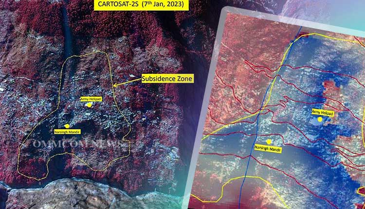
Joshimath, a town in Uttarakhand that is slowly sinking due to land subsidence, has been depicted in satellite images by the National Remote Sensing Centre of the Indian Space Research Organization. The images show a rapid subsidence of 5.4 cm that occurred between December 27, 2022, and January 8, 2023.
Since Joshimath experienced modest subsidence of 9 cm between April 2022 and November 2022, the 12-day sinking rate has been rapid. According to the NSRC, a rapid subsidence event began during the latter week of December and the first week of January.
The Army Helipad and Narsingh Mandir are the only two structures in the centre of Joshimath that are within the subsidence zone, according to satellite imagery. At a height of 2,180 m, the subsidence’s crown is situated close to the Joshimath-Auli route.
The Chamoli district administration declared Joshimath a land-subsidence zone after hundreds of homes developed cracks within a short period of time and residents were forced to move because their homes were deemed unsafe. The government has offered a temporary compensation package of Rs 1.5 lakh and is developing a restoration plan.
The government’s plans to start demolishing two hotels on Thursday were once again put on hold due to adverse weather. The locals’ and citizens’ protests had caused a temporary halt to the mechanical destruction.
According to the administration, only the Malari Inn and Mount View Hotels will be removed because their presence poses a threat to the other buildings. As of right now, no additional homes will be razed.
A number of specialist teams have been enlisted to investigate the sinking of Joshimath, and the experts are blaming tunnelling for the NTPC hydro project. In contrast, NTPC asserted in a statement that Joshimath is not directly beneath their tunnel.
Also Read: Ahmedabad: Over 1,000 Birds, Animals Injured In Past Mth Ahead Of Kite Festival


